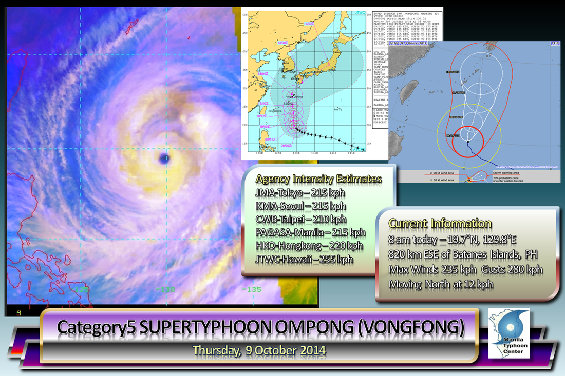
 The strongest tropical cyclone of the year (as of this writing), Super Typhoon OMPONG (Vongfong) is now laying its sights on the southern islands of Japan, the Ryukyu Islands.
The howler has begun to make its trek Northward and is possibly already past its peak intensity. As it passes near Okinawa, the Typhoon is possibly between a Cat 3 or 4. The typhoon will not directly affect the Philippines, but rough seas may be experienced by seafarers along the Eastern seaboards of Luzon and Samar. ManilaTC 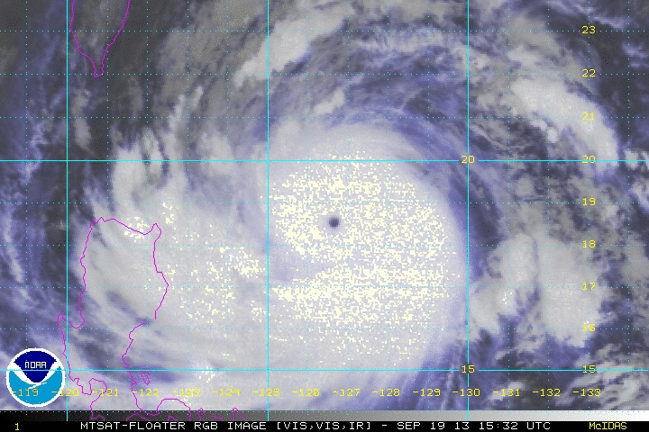 Click on image for animated loop Click on image for animated loop ODETTE (Usagi) has been given the SUPER TYPHOON title by JTWC-Hawaii and CMA-Beijing. The howler has now winds reaching 230 kph, a Strong Category-4 Typhoon on the Saffir-Sampson Scale. The Super Typhoon is now making its approach towards extreme Northern Luzon and Southern Taiwan, then go on its way towards Southern China-Hongkong area.
PAGASA TYPHOON WARNING SIGNALS (as of 5 am Warning) SIGNAL NUMBER 3 -- Batanes Group of Islands... meaning winds of 101-185 kph are expected in at least 18 hours SIGNAL NUMBER 2 -- Cagayan, Calayan and Babuyan Group of Islands, Apayao... meaning winds of 61-100 kph are expected in the next 24 hours SIGNAL NUMBER 1 -- Ilocos Norte, Ilocos Sur, Mt. Province, Ifugao, Abra, Kalinga, Isabela ... meaning winds of 45-60 kph are expected in the next 36 hours At 6 am today Manila time, The eye of ODETTE (Usagi) was last located at 19.1°N, 125.8°E... about 445 km East-Northeast of Aparri, Cagayan or 430 km East-Southeast of the Batanes Island Group... fix based on the ADT fixes... ODETTE (Usagi) is moving on a steady WEST-NORTHWEST to NORTHWEST TRACK at 20 kph INTENSITY ESTIMATES BY WEATHER AGENCIES PAGASA-Manila -- Max 175 kph Gust 210 kph (10 min-average) CMA-Beijing -- Max 220 kph Gust 265 kph (10 min-average) JMA-Tokyo -- Max 205 kph Gust 270 kph (10 min-average) KMA-Seoul -- Max 195 kph Gust 235 kph (10 min-average) JTWC-Hawaii -- Max 260 kph Gust 315 kph (1 min-average) CWB-Taiwan -- Max 200 kph Gust 240 kph (10 min-average) HKO-Hongkong -- Max 195 kph Gust 210 kph (10 min-average) *** PAGASA remains to be the lowest intensity among all the West Pacific agencies, and appears to avoid classifying storms above 185kph, its Signal 4 threshold. They keep underestimating. - Manila TC admin *** More info at the jump, so Click Read More.  Time and time again, the waters of the Philippine Sea have generated several major Typhoons due to its warm Sea Surface Temperatures (SST's).
Looks like ODETTE (Usagi) will be no exception. More at the jump. Click "Read More"...
SYNOPSIS
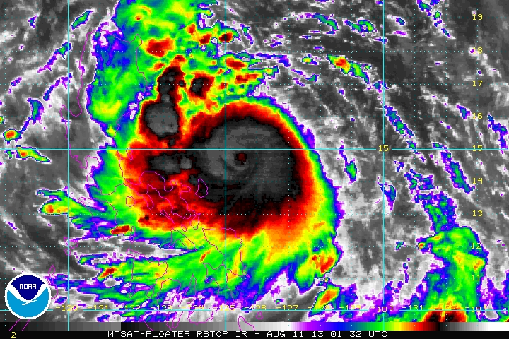
Dangerous and Intensifying Category 2 Typhoon LABUYO (UTOR) continues to tread closer to Eastern Luzon... Posing an increasing threat to Luzon. Interests in LUZON should closely monitor the progress of this Typhoon. Areas under the storm warnings should follow or track the severe weather potential of the storm not just the storm center. Severe weather meaning: Torrential Rainfall, Storm Surges and the potential of flooding and landslides... |
Archives
July 2016
AuthorThis is the official blog page of Manila Typhoon Center. All the latest advisories from ManilaTC will be coursed here should the Facebook page be inaccessible for any reason. Categories
All
|
Manila Typhoon Center - Your online resource for typhoon updates.

 RSS Feed
